Introduction | Projection detection | Installation | Using the tool | Samples | Supported projections | References
Samples
Map 1: Map of Europe, normal aspect of the projection
| Title: | L'Europe sous l'Empire de Charlemagne ou tableau historique de cette partie du monde |
| Author: | Adrien Huber |
| Date: | 1828, |
| Publisher: | A. Brue, |
| Location: | Paris, |
| Type: | Atlas Map, |
| Height: | 37 cm, |
| Width: | 51 cm, |
| Scale: | 1 : 12,500,000. |
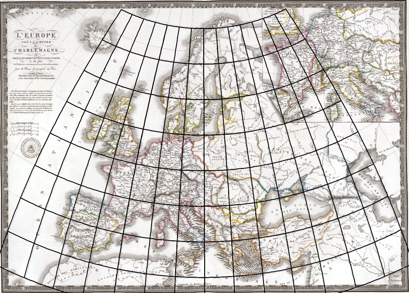
Determined parameters of the projection:
Projection: Bonne.
Transformed pole position: φk = 90.0○, λk = 0.0○.
Standard parallels: φ1 =53. 5○, φ2 =53. 5○.
Longitude of the central meridian: λ0 = 14.7○.
Arbitrary constant parameter: k = 1.0.
Auxiliary sphere radius: R′= 0.3m.
Map scale: S = 20 910 248.
Angle of rotation: α = 0.00.
Map 2: World map in hemisphere, transverse aspect of the projection
| Title: | Novus Orbis Sive America Meridionalis Et Septentrionalis : divisa per sua regna, provincias et insul, cura et opera |
| Author: | Seutter, Matthäus, |
| Date: | 1744 |
| Publisher: | Seutter, Matthäus, |
| Location: | Augsburg, |
| Type: | Atlas Map, |
| Height: | 58 cm, |
| Width: | 50 cm, |
| Scale: | 1 : 19,000,000 |
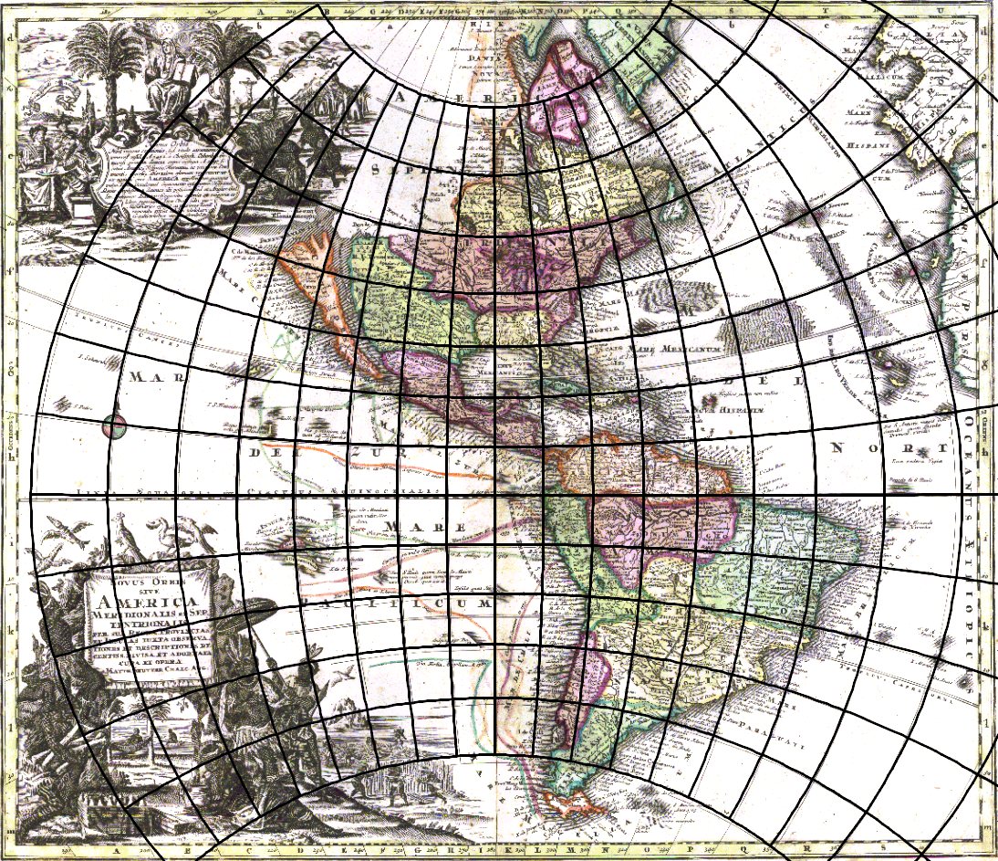
Determined parameters of the projection:
Projection:stereographic.
Transformed pole position: φk = 0.2○, λk = -80.3○.
Standard parallels: φ1 =0. 0○, φ2 =0.0○.
Longitude of the central meridian: λ0 = 0.0○.
Arbitrary constant parameter: k = 1.0.
Auxiliary sphere radius: R′= 2.2 m.
Map scale: S = 39 380 986.
Angle of rotation: α = 0.00.
Map 3: World in planisphere, oblique aspect of the projection
| Title: | World Air Routes. Nordic Projection By John Bartholomew, |
| Author: | Bartholomew, John, |
| Date: | 1958, |
| Publisher: | Houghton Mifflin Co., |
| Location: | Boston, |
| Type: | Atlas Map, |
| Height: | 49 cm, |
| Width: | 61 cm, |
| Scale: | 1 : 2,600,000 |
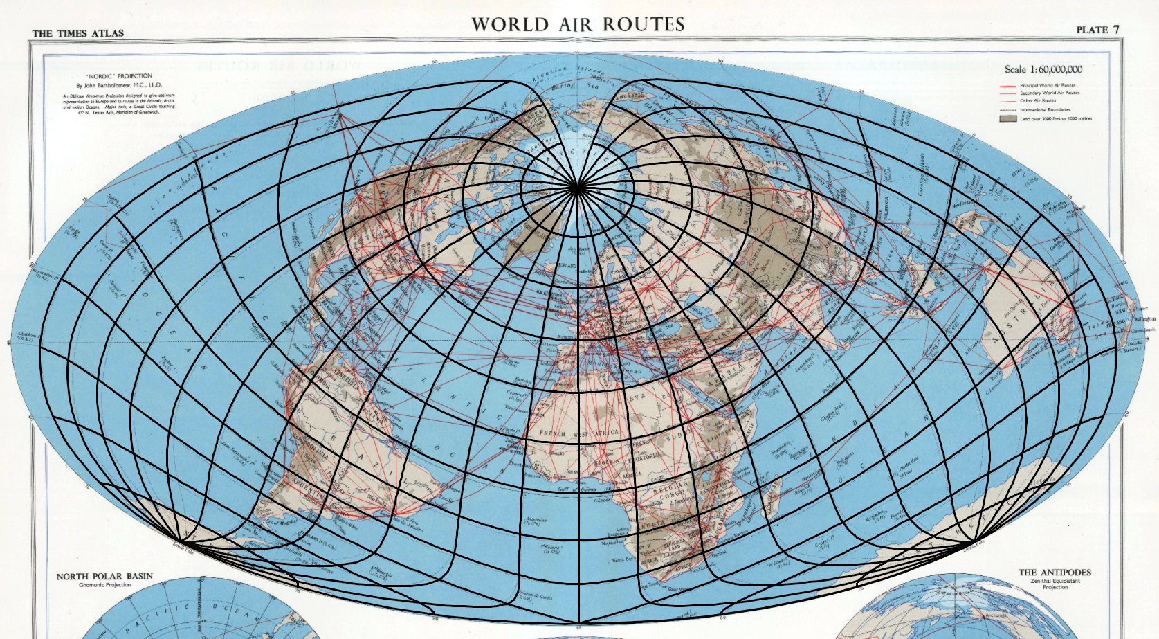
Determined parameters of the projection:
Projection: Hammer.
Transformed pole position: φk = 45.2○, λk = 179.7○.
Standard parallels: φ1 =0.0○, φ2 = 0.0○.
Longitude of the central meridian: λ0 = 0.0○.
Arbitrary constant parameter: k = 1.0.
Auxiliary sphere radius: R′= 0.1 m.
Map scale: S = 93 045 821.
Angle of rotation: α = 0.00.
Map 4: World map in planisphere, normal aspect of the projection
| Title: | Typus orbis terrarum. Ab. Ortelius describ. cum privilegio decennali 1587 |
| Author: | Ortelius, Abraham |
| Date: | 1828, |
| Publisher: | Hachette & Cie, |
| Location: | Paris, |
| Type: | Atlas Map, |
| Height: | 34 cm, |
| Width: | 51 cm, |
| Scale: | 1 : 90,000,000. |
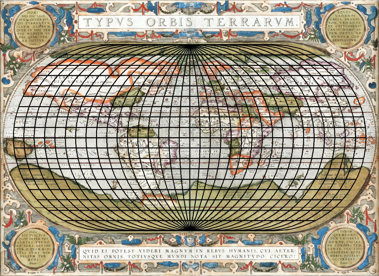
Determined parameters of the projection:
Projection: Ortelius.
Transformed pole position: φk = 90.0○, λk = 0.0○.
Standard parallels: φ1 =0.0○, φ2 = 0.0○.
Longitude of the central meridian: λ0 = 0.3○.
Arbitrary constant parameter: k = 1.0.
Auxiliary sphere radius: R′= 0.1 m.
Map scale: S = 102 676 746.
Angle of rotation: α = 0.00.
Map 5: World map in hemispheres, transverse aspect of the projection
| Title: | Nova Totium Terrarum Orbis Tabula, |
| Author: | Hondius, Henricus, |
| Date: | 1630, |
| Publisher: | Blaeu, Joan, |
| Location: | Amsterdam, |
| Type: | Atlas Map, |
| Height: | 58 cm, |
| Width: | 81 cm, |
| Scale: | 1 : 90,000,000. |
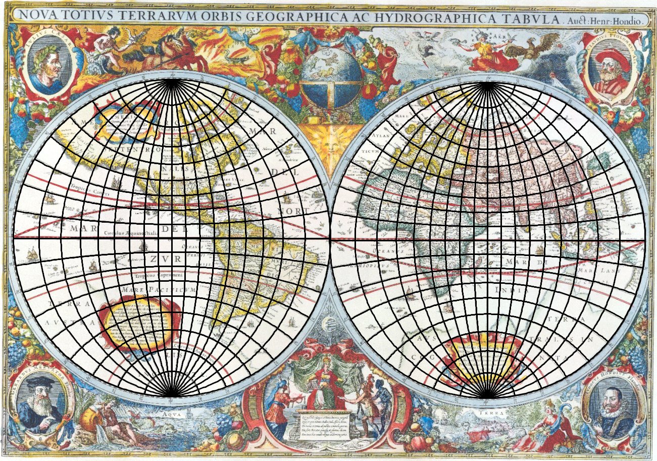
Determined parameters of the projection, Western Hemisphere:
Projection: stereographic.
Transformed pole position: φk = -0.1○, λk = -90.0○.
Standard parallels: φ1 =0.0○, φ2 = 0.0○.
Longitude of the central meridian: λ0 = 0.0○.
Arbitrary constant parameter: k = 1.0.
Auxiliary sphere radius: R′= 0.2 m.
Map scale: S = 26 255 473.
Angle of rotation: α = 0.00.
Determined parameters of the projection, Eastern Hemisphere:
Projection: stereographic.
Transformed pole position: φk = 0.1○, λk = 90.0○.
Standard parallels: φ1 =0.0○, φ2 = 0.0○.
Longitude of the central meridian: λ0 = 0.0○.
Arbitrary constant parameter: k = 1.0.
Auxiliary sphere radius: R′= 0.2 m.
Map scale: S = 26 376 592.
Angle of rotation: α = 0.00.